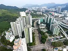
Tai Wai Nullah (centre) passing through Mei Lam Estate.

Tai Wai Nullah passing through Tai Wai.

Junction of Tai Wai Nullah and Shing Mun River.
Tai Wai Nullah (Chinese: 大圍渠), sometimes referred to as the upper stream of Shing Mun River,[1] is one of the nullahs of Shing Mun River in Tai Wai of Hong Kong.
The channelised nullah has a width of about 39 m. As water flow is very low most of the time, the concrete nullah bed is exposed.[1]
See also
References
Further reading
Wikimedia Commons has media related to Tai Wai Nullah.
- Chuk, Lin-ping, "Reconnecting over nullah : community foci at Tai Wai", Postgraduate Thesis, Master of Architecture, University of Hong Kong, 1998
- Wong, Yin Kiu (June 2015). Back to the root : Hong Kong urban river revitalization (Master of Landscape Architecture). The University of Hong Kong. doi:10.5353/th_b5558701. hdl:10722/216311.
22°22′44″N 114°10′35″E / 22.378912°N 114.176518°E
This article is issued from Wikipedia. The text is licensed under Creative Commons - Attribution - Sharealike. Additional terms may apply for the media files.