Saint-Symphorien-des-Bruyères | |
|---|---|
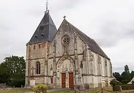 The church in Saint-Symphorien-des-Bruyères | |
Location of Saint-Symphorien-des-Bruyères | |
 Saint-Symphorien-des-Bruyères 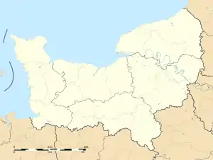 Saint-Symphorien-des-Bruyères | |
| Coordinates: 48°47′21″N 0°35′00″E / 48.7892°N 0.5833°E | |
| Country | France |
| Region | Normandy |
| Department | Orne |
| Arrondissement | Mortagne-au-Perche |
| Canton | Rai |
| Intercommunality | Pays de l'Aigle |
| Government | |
| • Mayor (2020–2026) | Guy Martel[1] |
| Area 1 | 16.02 km2 (6.19 sq mi) |
| Population | 473 |
| • Density | 30/km2 (76/sq mi) |
| Time zone | UTC+01:00 (CET) |
| • Summer (DST) | UTC+02:00 (CEST) |
| INSEE/Postal code | 61457 /61300 |
| Elevation | 230–294 m (755–965 ft) (avg. 246 m or 807 ft) |
| 1 French Land Register data, which excludes lakes, ponds, glaciers > 1 km2 (0.386 sq mi or 247 acres) and river estuaries. | |
Saint-Symphorien-des-Bruyères (French pronunciation: [sɛ̃ sɛ̃fɔʁjɛ̃ de bʁɥijɛʁ] ⓘ) is a commune in the Orne department in north-western France.[3]
Points of interest
National heritage sites
- Église Saint-Symphorien de Saint-Symphorien-des-Bruyères a fifteenth centaury church, it was registered as a Monument historique 1926.[4]
See also
References
- ↑ "Répertoire national des élus: les maires". data.gouv.fr, Plateforme ouverte des données publiques françaises (in French). 9 August 2021.
- ↑ "Populations légales 2021". The National Institute of Statistics and Economic Studies. 28 December 2023.
- ↑ "Commune de Saint-Symphorien-des-Bruyères (61457) − COG | Insee". www.insee.fr.
- ↑ "Eglise à Saint-Symphorien-des-Bruyères - PA00110938". monumentum.fr.
Wikimedia Commons has media related to Saint-Symphorien-des-Bruyères.
This article is issued from Wikipedia. The text is licensed under Creative Commons - Attribution - Sharealike. Additional terms may apply for the media files.