Panské Dubenky | |
|---|---|
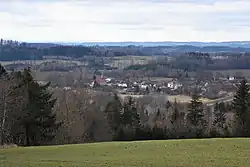 View from the east | |
 Flag  Coat of arms | |
 Panské Dubenky Location in the Czech Republic | |
| Coordinates: 49°13′11″N 15°15′57″E / 49.21972°N 15.26583°E | |
| Country | |
| Region | Vysočina |
| District | Jihlava |
| First mentioned | 1350 |
| Area | |
| • Total | 3.41 km2 (1.32 sq mi) |
| Elevation | 627 m (2,057 ft) |
| Population (2023-01-01)[1] | |
| • Total | 129 |
| • Density | 38/km2 (98/sq mi) |
| Time zone | UTC+1 (CET) |
| • Summer (DST) | UTC+2 (CEST) |
| Postal code | 588 05 |
| Website | pdubenky |
Panské Dubenky (Czech pronunciation: [ˈpanskɛː ˈdubɛŋkɪ]) is a municipality and village in Jihlava District in the Vysočina Region of the Czech Republic. It has about 100 inhabitants.
Panské Dubenky lies approximately 31 kilometres (19 mi) south-west of Jihlava and 115 km (71 mi) south-east of Prague.
References
Wikimedia Commons has media related to Panské Dubenky.
This article is issued from Wikipedia. The text is licensed under Creative Commons - Attribution - Sharealike. Additional terms may apply for the media files.