
Nygränd in March 2007.
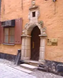
Number 2.
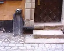
A medieval waste pipe next to the front door of Number 2.
Nygränd (Swedish: New Alley) is an alley in Gamla stan, the old town of Stockholm, Sweden, connecting Skeppsbron to Österlånggatan.
- Old names
- Niia grenden (1553), Nygrenden (1570)
Until the early 1520s, a fish market (Fisketorget, "The Fisherman's Square") was located between the site of the present alley and the alley south of it, Brunnsgränd, the square at the time forming a natural continuation to Köpmangatan ("The Merchant's Street"), the street leading east from the central square Stortorget.[1]
One of the old town's most elaborate portals is found on 2, Nygränd.[2]
- Parallel streets
- Kråkgränd, Brunnsgränd
- Crossing streets
- Skeppsbron, Österlånggatan
References
- ↑ "Innerstaden: Gamla stan". Stockholms gatunamn (2nd ed.). Stockholm: Kommittén för Stockholmsforskning. 1992. p. 64. ISBN 91-7031-042-4.
- ↑ Nordisk familjebok. Project Runeberg. 1917. Retrieved 2007-01-18.
See also
Wikimedia Commons has media related to Nygränd.
59°19′30.1″N 18°04′29.2″E / 59.325028°N 18.074778°E
This article is issued from Wikipedia. The text is licensed under Creative Commons - Attribution - Sharealike. Additional terms may apply for the media files.