| De Loonse en Drunense Duinen National Park | |
|---|---|
| Nationaal Park De Loonse en Drunense Duinen | |
Aerial video of the Loonse en Drunese Duinen area. | |
| Location | North Brabant, Netherlands |
| Coordinates | 51°38′52″N 5°06′53″E / 51.64778°N 5.11472°E |
| Area | 35 km2 (14 sq mi) |
| Established | 2002[1] |

Detail map
Loonse en Drunense Duinen
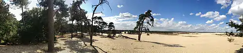
De Loonse en Drunense Duinen National Park (duinen = dunes) is a national park situated in the south of the Netherlands, between the cities of Tilburg, Waalwijk and 's-Hertogenbosch. It has been designated as a national park since 2002. It is 35 km² (14 mile²) in area, and located in the municipalities of Loon op Zand, Heusden, and Vught.
The Loonse en Drunense Duinen consists of forests and very large dunes, creating an extraordinary microclimate.
References
- ↑ (in Dutch) https://nationaalpark.nl/park/nationaal-park-loonse-en-drunense-duinen/ Nationaal park Loonse en Drunense Duinen
External links
Wikimedia Commons has media related to Loonse en Drunense Duinen.
This article is issued from Wikipedia. The text is licensed under Creative Commons - Attribution - Sharealike. Additional terms may apply for the media files.