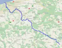
| Parsęta | |
|---|---|
 Parsęta near Karlino | |
 | |
| Location | |
| Country | Poland |
| Physical characteristics | |
| Source | |
| • location | Parsęcko near Szczecinek |
| • coordinates | 53°43′9″N 16°35′12″E / 53.71917°N 16.58667°E |
| • elevation | 137 m (449 ft) |
| Mouth | |
• location | Baltic Sea at Kołobrzeg |
• coordinates | 54°11′18″N 15°33′4″E / 54.18833°N 15.55111°E |
| Length | 143 km (89 mi) |
| Basin size | 3,084 km2 (1,191 sq mi) |
| Discharge | |
| • average | 29.1 m3/s (1,030 cu ft/s) |
Parsęta (Polish pronunciation: [parˈsɛnta]; German: Persante pronounced [pɛʁˈzantə]) is a river in the West Pomeranian Voivodeship (Zachodniopomorskie) of north-western Poland, with a length of 143 km (89 mi) and a basin area of 3,084 km2 (1,191 sq mi).[1] It flows into the Baltic Sea.
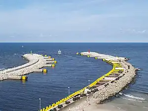
Parsęta - Port of Kołobrzeg (August 2010)
Towns:
Tributaries:
See also
References
Wikimedia Commons has media related to Parsęta.
This article is issued from Wikipedia. The text is licensed under Creative Commons - Attribution - Sharealike. Additional terms may apply for the media files.