Maya Cablecar funicular
Maya Cablecar Station
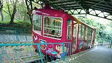
The Maya Cablecar, officially the Maya Cable Line (摩耶ケーブル線, Maya Kēburu-sen) is a Japanese funicular line in Kobe, Hyōgo, operated by the public company Kōbe City Urban Development. The line opened in 1925, originally as a route to Tōri Tenjō-ji temple on Mount Maya. Now the line is used to see the scenic view of Kobe. Together with Maya Ropeway, the line has an official nickname Maya View Line Yume-Sanpo (まやビューライン夢散歩, Maya Byū Rain Yume-Sanpo, "Maya View Line Dreamy Stroll").
Basic data
stations
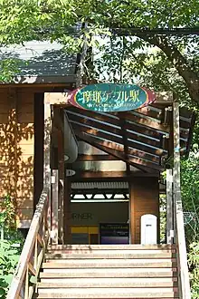
- Maya Cable Eki (摩耶ケーブル駅)
- Niji no Eki (虹の駅) (halfway up Mount Maya)
Surroundings
- Hyogo Prefectural Kobe High School (兵庫県立神戸高等学校)
- The tunnel of cherry trees (桜のトンネル)[1]
Buses
- Kobe City Bus
- Route 18 (westbound) for Kobe-sannomiya Station (三宮駅) and Rokkōmichi Station (六甲道駅)
- Route 102 (eastbound) for Rokkōmichi Station (六甲道駅)
- Kobe Minato Kanko Bus
- Maya View Line Saka Bus (まやビューライン坂バス) for Nada Station (灘駅)
See also
References
External links
Wikimedia Commons has media related to Maya Cablecar.
- Maya View Line Yume-Sanpo official website (in Japanese)
- Kōbe City Urban Development official website (in Japanese)
34°43′37.1″N 135°12′44.5″E / 34.726972°N 135.212361°E
This article is issued from Wikipedia. The text is licensed under Creative Commons - Attribution - Sharealike. Additional terms may apply for the media files.