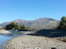
The Eyre Creek with the Mid Dome in the background
.JPG.webp)
Black-billed gull
The Eyre Creek is a river in the Southland region of New Zealand's South Island. It is a tributary of the Mataura River with a braided channel and with its confluence near the small town of Athol. It rises on the eastern side of Jane Peak in the Eyre Mountains south-west of Lake Wakatipu. It has been identified as an Important Bird Area by BirdLife International because it supports breeding colonies of the endangered black-billed gull.[1] West of Athol it is crossed by State Highway 6 and the Around the Mountains Cycle Trail.
References
- ↑ "Eyre Creek". BirdLife data zone: Important Bird Areas. BirdLife International. 2012. Archived from the original on 10 July 2007. Retrieved 14 November 2012.
45°31′40″S 168°33′33″E / 45.52778°S 168.55917°E
This article is issued from Wikipedia. The text is licensed under Creative Commons - Attribution - Sharealike. Additional terms may apply for the media files.