| Bleibtreusee | |
|---|---|
 | |
 Bleibtreusee | |
| Location | Rhein-Erft-Kreis, North Rhine-Westphalia |
| Coordinates | 50°50′23″N 06°51′35″E / 50.83972°N 6.85972°E |
| Basin countries | Germany |
| Surface area | 74.2 ha (183 acres) |
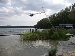
Bleibtreusee is an artificial lake on the grounds of the former open-pit lignite mine in Rhein-Erft-Kreis, North Rhine-Westphalia, Germany. At an elevation of its surface area is 74.2 ha. North of Bleibtreusee, there is an electricity pylon, which carried from 1977 to 2010 an observation deck.
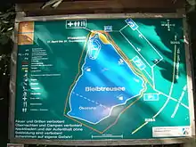
General Plan (2013-07-21)
Wikimedia Commons has media related to Bleibtreusee.
This article is issued from Wikipedia. The text is licensed under Creative Commons - Attribution - Sharealike. Additional terms may apply for the media files.