
Location of Greenwich Island in the South Shetland Islands
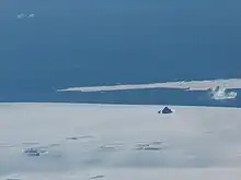
Archar Peninsula

Topographic map of Livingston Island, Greenwich, Robert, Snow and Smith Islands
Archar Peninsula (Bulgarian: полуостров Арчар, romanized: poluostrov Archar, IPA: [poɫuˈɔstrof ɐrˈt͡ʃar]) located in the North-Western extremity of Greenwich Island, Antarctica. The three km long peninsula is bounded by Razlog Cove to the North and McFarlane Strait to the South. Its western half is snow-free in summer. The peninsula is named after the settlement of Archar in Northwestern Bulgaria, successor of the ancient town of Ratiaria.
See also
Maps
- South Shetland Islands. Scale 1:200000 topographic map. DOS 610 Sheet W 62 58. Tolworth, UK, 1968.
- South Shetland Islands. Scale 1:200000 topographic map. DOS 610 Sheet W 62 60. Tolworth, UK, 1968.
- L.L. Ivanov et al. Antarctica: Livingston Island and Greenwich Island, South Shetland Islands. Scale 1:100000 topographic map. Sofia: Antarctic Place-names Commission of Bulgaria, 2005.
- L.L. Ivanov. Antarctica: Livingston Island and Greenwich, Robert, Snow and Smith Islands. Scale 1:120000 topographic map. Troyan: Manfred Wörner Foundation, 2009. ISBN 978-954-92032-6-4
- Antarctic Digital Database (ADD). Scale 1:250000 topographic map of Antarctica. Scientific Committee on Antarctic Research (SCAR). Since 1993, regularly updated.
- L.L. Ivanov. Antarctica: Livingston Island and Smith Island. Scale 1:100000 topographic map. Manfred Wörner Foundation, 2017. ISBN 978-619-90008-3-0
References
- Archar Peninsula. SCAR Composite Gazetteer of Antarctica.
- Bulgarian Antarctic Gazetteer. Antarctic Place-names Commission. (details in Bulgarian, basic data in English)
External links
- Archar Peninsula. Copernix satellite image
This article includes information from the Antarctic Place-names Commission of Bulgaria which is used with permission.
62°27′30″S 60°00′00″W / 62.45833°S 60.00000°W
This article is issued from Wikipedia. The text is licensed under Creative Commons - Attribution - Sharealike. Additional terms may apply for the media files.